El Hierro
Day Two - North and West Coast
16/12/07 19:59
Not a particularly early start but when I got down to breakfast at just before 9 it was a bit busy. I decided to skip breakfast and set off.
I drove back to the airport via the spectacular La Frontera road. It is the slow route, as I later discovered, but visually stunning. At the airport I returned the car. It had 69k on the clock and the brakes were a bit suspect. They gave me another car of the same type with half the mileage
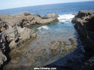
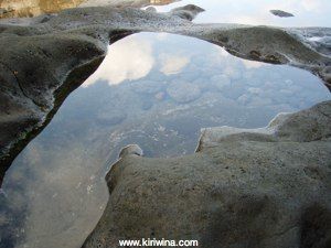
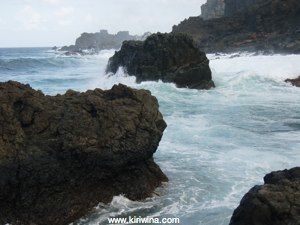
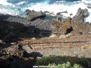
First stop was Charco Manso on the north coast. There are very few beaches on El Hierro so for swimming they use some spectacular natural rock pools formed in the lava flows. Usually these are enhanced enhanced with bathing ladders, access paths and seating areas as well as some structural modifications. They are generally flushed by wave action so the water is clear and clean.
An overview of the pool at Charco Manso looking seaward.
Looking back at the access paths and parking area.
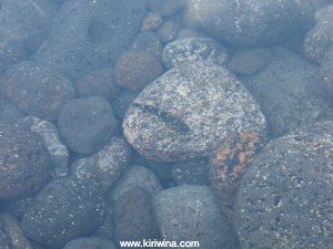
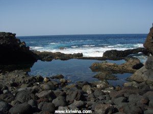
As the tide ebbs drainage is not complete and residual pools, complete with little fish remain in the rock.
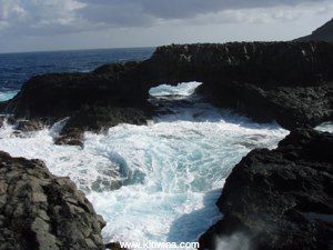
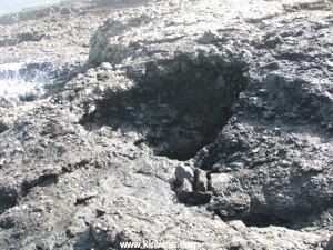
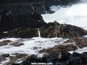
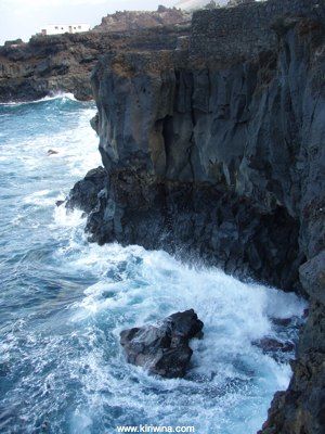
The lava flow in which Charco Manso is situated is a maze of caves, holes, lava bridges and cliffs. Quite wonderful.
This coast is exposed to big swells from the north so there is a lot of wave action. Here the water is draining away...
....then back it comes with the next wave.
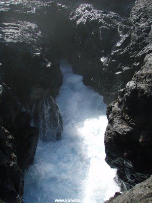
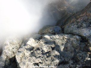
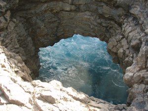
Water mist escaping from a blowhole about a foot in diameter. As the sea fills the cave below air is forced through the blowhole at a fierce rate. If standing too close one could easily be blown over.
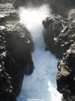
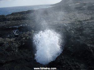
Another bigger blowhole which looks pretty harmless...
...until it blows.
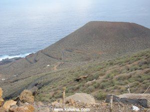
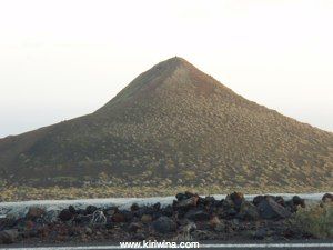
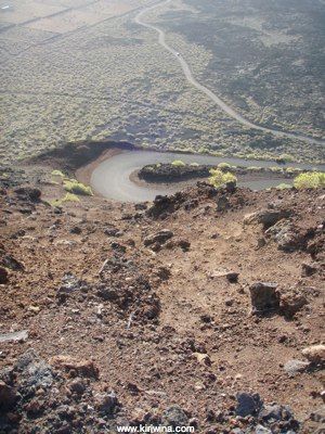
El Hierro has 500 visible volcanic cones, more than any other Canary island. This one is near Charco Manso with he access road winding down it's slope.
Not far along the coast heading west is the village of Pozo de las Calcosas. It is a holiday and weekend village with thatched drystone houses.
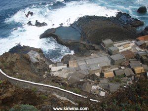
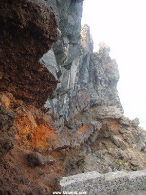
Access is via a long winding path cut into the cliff. The variety of volcanic rubble is clearly visible.
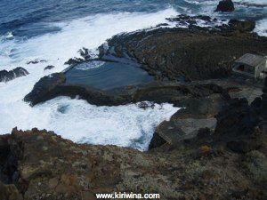
A closer look at the bathing pool. A small wave has just broken over the pool wall. An adjacent lava flow is clearly visible.
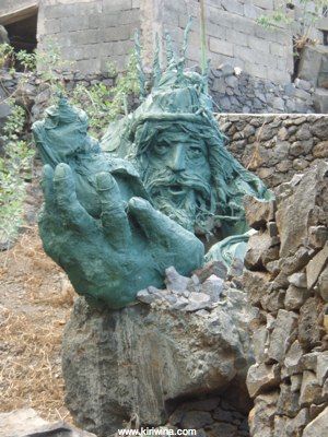
Somebody had created this sculpture in fibreglass next to the path. King Neptune?
As in most of the islands the water is very deep close inshore and shelves steeply. The waves break very close in.
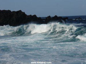
The ebb between waves...
...and then the next wave breaks.
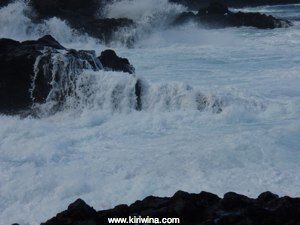
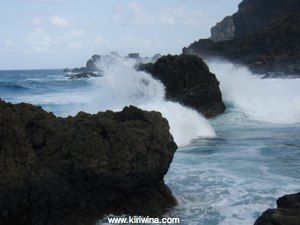
This is a really violent piece of coast.
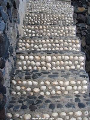
Stairway leading to one of the houses.
King Neptune from another angle on the way up.
I wanted to stop at Mirador de la Peña but the road map issued by Cicar was a little dated and omitted a new tunnel which leads from the north coast into El Golfo.I ended up in El Golfo driving along the coast road.
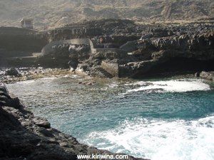
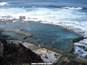
There are some more rock pools here. This one is at La Maceta. The children line up on the pool wall and wait for the next wave to sweep them back into the pool.
Further along, Charco Azul was a smaller pool at the bottom of a steep cliff.
The pool was smaller but sunning platforms and a seating area had been built. There were only four people there. It was right next to a large sea cave.
Back at the hotel I had booked in for a stress relief treatment. Not because I was particularly stressed, or indeed stressed at all. I was curious.
My therapist was a Swiss lady who now lived in El Hierro.
The treatment was interesting. Firstly I was rubbed down with what was essentially liquid sandpaper. Then I had to sit in a saltwater bath for 20 minutes. After this I was rubbed down with some oily substance produced by a french company I had never heard of. After the treament I felt a bit sticky all over from the oil.
I don't know about anti stress but I think my skin ended up a bit smoother.
Back in the car and through the impressive El Golfo tunnel bound for the Mirador de la Peña.
Roque Salmor seen from Mirador de la Peña on the north west coast.
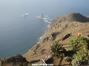
Looking more or less south towards El Golfo. From the Mirador down it is almost vertical.
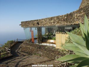
The restaurant at Mirador de la Peña designed by César Manrique.
To reach La Restinga on the southernmost point of the island I passed through San Andres and El Pinar. This routed skirted the forested central plateau and passed through the much more volcanic south eastern "el Rio" area.
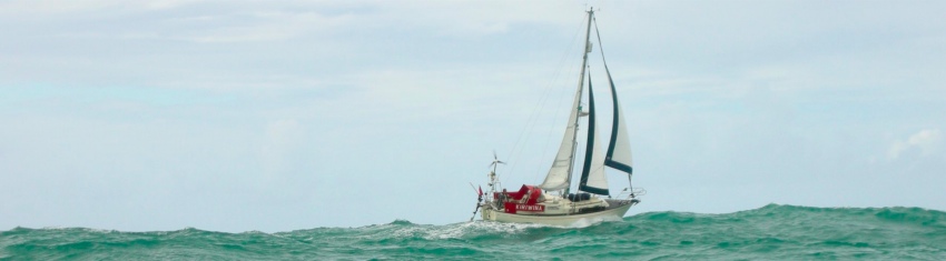
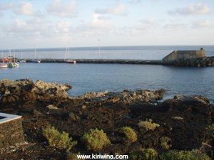
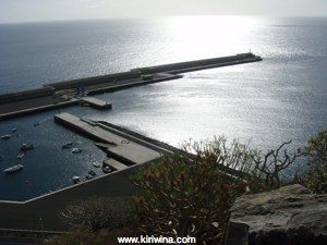
La Restinga is a very sleepy little place and not a lot seemed to be going on when I was there or, I suspect, at any time. The harbour was quite large with several visiting yachts moored alongside the outer breakwater which was fitted with large rubber fenders. I didn't like the look of these and think I would only leave the boat in settled conditions.
La Restinga harbour.
A volcanic cone just north of La Restinga.
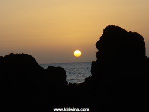
Sunset at Cala de Tacaron to the west of La Restinga.
By now it was dark and I drove back across the island through the forest and down the Frontera road to Pozo de Salud.
I drove back to the airport via the spectacular La Frontera road. It is the slow route, as I later discovered, but visually stunning. At the airport I returned the car. It had 69k on the clock and the brakes were a bit suspect. They gave me another car of the same type with half the mileage
First stop was Charco Manso on the north coast. There are very few beaches on El Hierro so for swimming they use some spectacular natural rock pools formed in the lava flows. Usually these are enhanced enhanced with bathing ladders, access paths and seating areas as well as some structural modifications. They are generally flushed by wave action so the water is clear and clean.
An overview of the pool at Charco Manso looking seaward.
Looking back at the access paths and parking area.
As the tide ebbs drainage is not complete and residual pools, complete with little fish remain in the rock.
The lava flow in which Charco Manso is situated is a maze of caves, holes, lava bridges and cliffs. Quite wonderful.
This coast is exposed to big swells from the north so there is a lot of wave action. Here the water is draining away...
....then back it comes with the next wave.
Water mist escaping from a blowhole about a foot in diameter. As the sea fills the cave below air is forced through the blowhole at a fierce rate. If standing too close one could easily be blown over.
Another bigger blowhole which looks pretty harmless...
...until it blows.
El Hierro has 500 visible volcanic cones, more than any other Canary island. This one is near Charco Manso with he access road winding down it's slope.
Not far along the coast heading west is the village of Pozo de las Calcosas. It is a holiday and weekend village with thatched drystone houses.
Access is via a long winding path cut into the cliff. The variety of volcanic rubble is clearly visible.
A closer look at the bathing pool. A small wave has just broken over the pool wall. An adjacent lava flow is clearly visible.
Somebody had created this sculpture in fibreglass next to the path. King Neptune?
As in most of the islands the water is very deep close inshore and shelves steeply. The waves break very close in.
The ebb between waves...
...and then the next wave breaks.
This is a really violent piece of coast.
Stairway leading to one of the houses.
King Neptune from another angle on the way up.
I wanted to stop at Mirador de la Peña but the road map issued by Cicar was a little dated and omitted a new tunnel which leads from the north coast into El Golfo.I ended up in El Golfo driving along the coast road.
There are some more rock pools here. This one is at La Maceta. The children line up on the pool wall and wait for the next wave to sweep them back into the pool.
Further along, Charco Azul was a smaller pool at the bottom of a steep cliff.
The pool was smaller but sunning platforms and a seating area had been built. There were only four people there. It was right next to a large sea cave.
Back at the hotel I had booked in for a stress relief treatment. Not because I was particularly stressed, or indeed stressed at all. I was curious.
My therapist was a Swiss lady who now lived in El Hierro.
The treatment was interesting. Firstly I was rubbed down with what was essentially liquid sandpaper. Then I had to sit in a saltwater bath for 20 minutes. After this I was rubbed down with some oily substance produced by a french company I had never heard of. After the treament I felt a bit sticky all over from the oil.
I don't know about anti stress but I think my skin ended up a bit smoother.
Back in the car and through the impressive El Golfo tunnel bound for the Mirador de la Peña.
Roque Salmor seen from Mirador de la Peña on the north west coast.
Looking more or less south towards El Golfo. From the Mirador down it is almost vertical.
The restaurant at Mirador de la Peña designed by César Manrique.
To reach La Restinga on the southernmost point of the island I passed through San Andres and El Pinar. This routed skirted the forested central plateau and passed through the much more volcanic south eastern "el Rio" area.
La Restinga is a very sleepy little place and not a lot seemed to be going on when I was there or, I suspect, at any time. The harbour was quite large with several visiting yachts moored alongside the outer breakwater which was fitted with large rubber fenders. I didn't like the look of these and think I would only leave the boat in settled conditions.
La Restinga harbour.
A volcanic cone just north of La Restinga.
Sunset at Cala de Tacaron to the west of La Restinga.
By now it was dark and I drove back across the island through the forest and down the Frontera road to Pozo de Salud.
Day One - East and South Coast
15/12/07 19:57
I had booked a civilised departure time of 10:30 which meant that I could avoid taxis and use the excellent Tenerife bus system to get to Tenerife North Airport.
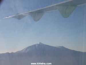
Our flight passed quite close to El Teide now dusted with snow from recent cooler weather.
The flight was on time and I rented another car from Cicar at the tiny and charming little airport on El Hierro. I set off down the east coast.
Puerto de la Estaca
Mainly used by ferries but with a small inner harbour for local craft. It looked pretty exposed to me and there were no visiting yachts.
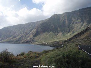
Further down the coast the road passed through a long tunnel emerging adjacent to Roque de la Bonanza.
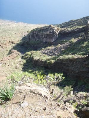
Looking south from the same spot the road goes as far as a parador hotel and comes to a dead end. El Hierro is very steep sided with little in the way of coastal plain and a flatish forested area on top.
Retracing my route I then took the high road towards Isora.
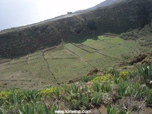
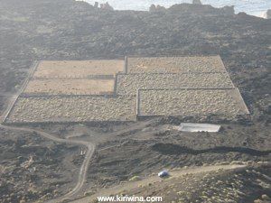
At some point the floor of this crater had been farmed but now the fields appeared fallow.
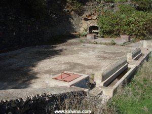
This, I think, is the Fuente de Azofa, a one time source of drinking water which is reached by going down a very steep path.
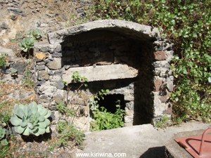
A large concrete tank had been added and parts had collapsed which only became apparent as I walked across it. The water inside didn't look too fresh.
A steep valley down to the sea from Fuente de Azofa.
I then moved on to the Mirador de Isora. Here looking down on Roque de la Bonanza which I had passed earlier.
Looking south from Mirador de Isora.
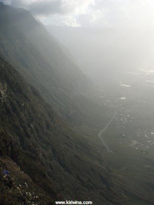
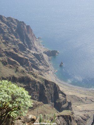
I hadn't booked a hotel and decided on Hotel Balneairo at Pozo de Salud. On the way there I stopped at Mirador de Jinama and peered down into a partially obscured El Golfo. This is a sort of dish shaped indent into the west coast with a flatish coastal plain. It was formed when a bit of El Hierro fell off into the sea. Quite a big bit actually. Some 300 cubic kilometres.
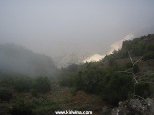
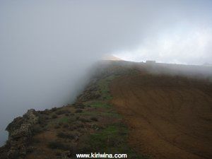
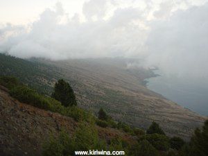
Cloud sweeping up from El Golfo.
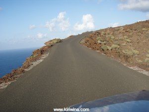
The road down into El Golfo via Frontera is a quite stunning switchback road requiring careful driving as roadside barriers are largely absent. The upper route from Frontera to Pozo de la Salud is similar, particularly the final section.
Hotel Balneairo was built about twenty years ago and is owned by the local council. It lay closed for 10 years after it was built but is now open with a variety of health spa services.
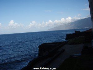
The view looking south from my room at Hotel Balneairo.
And looking north.
Hotel interior level 2.
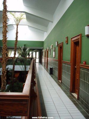
Level 1.

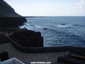
A sea cave almost under the hotel.
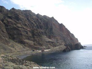
Checked in and with my bag in the room I set off to explore the south coast. Playa de Arena was not far from the hotel. This is pretty much as far west as one can get in Europe and until Greenwich was accepted as the prime meridian the westernmost point of El Hierro was one of several Meridiano Cero's.
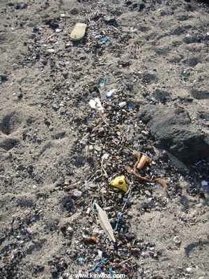
Playa de Arena is a remote and wild beach yet even here there was a large amount of plastic debris along the high water line. This is something I have seen on many remote beaches in Spain. Busy popular tourist beaches are cleaned regularly.
A rock bridge near Playa de Arena.
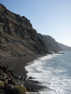
Playa del Ferodal, the largest beach on El Hierro and situated on the south west corner. The black "sand" is really small black pebbles rather than sand.
Another abandoned agricultural enterprise near Playa del Ferodal.
Looking down on the road to Playa del Ferodal.
The road up from Playa del Ferodal to the central plateau. It's a long way down on both sides.
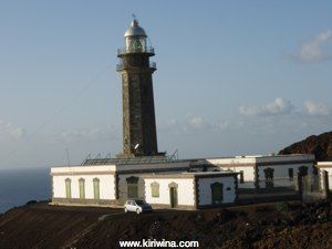
Approaching Faro de Orchilla by road.
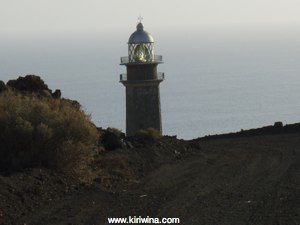
Another of the many fine Spanish lighthouses, Faro de Orchilla. Once tended by a lighthouse keeper but now operated remotely. As often seen with lighthouses in Galicia this building, sadly, now suffers from vandalism and graffiti.
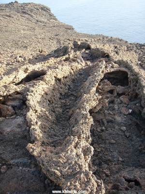
Volcanic tubes near Faro de Orchilla.
Your taxes at work! A small dock, Embarcadero de Orchilla, just along the coast from Faro de Orchilla with elaborate landscaping and built with EU funding. It's purpose was unclear.

Up on the central plateau the land was much flatter and in the southwest covered with scrubby forest. Not all the roads were paved.

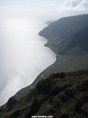
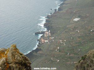
Mirador de Bascos gave a breathtaking view of El Golfo and of my hotel way down on the coast.
Looking along the SE coast.
Then drove through the forest and back to the hotel along the Frontera road in the dark.
Our flight passed quite close to El Teide now dusted with snow from recent cooler weather.
The flight was on time and I rented another car from Cicar at the tiny and charming little airport on El Hierro. I set off down the east coast.
Puerto de la Estaca
Mainly used by ferries but with a small inner harbour for local craft. It looked pretty exposed to me and there were no visiting yachts.
Further down the coast the road passed through a long tunnel emerging adjacent to Roque de la Bonanza.
Looking south from the same spot the road goes as far as a parador hotel and comes to a dead end. El Hierro is very steep sided with little in the way of coastal plain and a flatish forested area on top.
Retracing my route I then took the high road towards Isora.
At some point the floor of this crater had been farmed but now the fields appeared fallow.
This, I think, is the Fuente de Azofa, a one time source of drinking water which is reached by going down a very steep path.
A large concrete tank had been added and parts had collapsed which only became apparent as I walked across it. The water inside didn't look too fresh.
A steep valley down to the sea from Fuente de Azofa.
I then moved on to the Mirador de Isora. Here looking down on Roque de la Bonanza which I had passed earlier.
Looking south from Mirador de Isora.
I hadn't booked a hotel and decided on Hotel Balneairo at Pozo de Salud. On the way there I stopped at Mirador de Jinama and peered down into a partially obscured El Golfo. This is a sort of dish shaped indent into the west coast with a flatish coastal plain. It was formed when a bit of El Hierro fell off into the sea. Quite a big bit actually. Some 300 cubic kilometres.
Cloud sweeping up from El Golfo.
The road down into El Golfo via Frontera is a quite stunning switchback road requiring careful driving as roadside barriers are largely absent. The upper route from Frontera to Pozo de la Salud is similar, particularly the final section.
Hotel Balneairo was built about twenty years ago and is owned by the local council. It lay closed for 10 years after it was built but is now open with a variety of health spa services.
The view looking south from my room at Hotel Balneairo.
And looking north.
Hotel interior level 2.
Level 1.
A sea cave almost under the hotel.
Checked in and with my bag in the room I set off to explore the south coast. Playa de Arena was not far from the hotel. This is pretty much as far west as one can get in Europe and until Greenwich was accepted as the prime meridian the westernmost point of El Hierro was one of several Meridiano Cero's.
Playa de Arena is a remote and wild beach yet even here there was a large amount of plastic debris along the high water line. This is something I have seen on many remote beaches in Spain. Busy popular tourist beaches are cleaned regularly.
A rock bridge near Playa de Arena.
Playa del Ferodal, the largest beach on El Hierro and situated on the south west corner. The black "sand" is really small black pebbles rather than sand.
Another abandoned agricultural enterprise near Playa del Ferodal.
Looking down on the road to Playa del Ferodal.
The road up from Playa del Ferodal to the central plateau. It's a long way down on both sides.
Approaching Faro de Orchilla by road.
Another of the many fine Spanish lighthouses, Faro de Orchilla. Once tended by a lighthouse keeper but now operated remotely. As often seen with lighthouses in Galicia this building, sadly, now suffers from vandalism and graffiti.
Volcanic tubes near Faro de Orchilla.
Your taxes at work! A small dock, Embarcadero de Orchilla, just along the coast from Faro de Orchilla with elaborate landscaping and built with EU funding. It's purpose was unclear.
Up on the central plateau the land was much flatter and in the southwest covered with scrubby forest. Not all the roads were paved.
Mirador de Bascos gave a breathtaking view of El Golfo and of my hotel way down on the coast.
Looking along the SE coast.
Then drove through the forest and back to the hotel along the Frontera road in the dark.